Kingsley Plantation Shoreline Restoration Project
Overview
The Kingsley Plantation Shoreline Restoration Project was initiated to aid in the restoration of the shoreline and oysterbeds affected by boat traffic and severe storms. Below is an ArcGIS Interactive Map and a 3D interactive tour of the project, which was created to give visitors an immersive tour of the site. Please be advised the ArcGIS map and the 3D tour do not contain audio.
The Research Technology Services (RTS) staff worked with project facilitators to provide detailed aerial imagery for the design and implementation of the restoration strategies.
Persons with disabilities who need additional assistance with the interactive portions of this page, please contact Research Technology Services staff at rts@unf.edu.
ArcGIS Interactive Map
Text Transcript for ArcGIS Map
-
Kingsley Plantation ArcGIS Interactive Map
The following interactive map allows visitors to navigate the two renovation areas at Kingsley Plantation. Visitors can zoom in/out and pan around the two areas to view the current orthorectified aerial imagery of each area.
3D Virtual Tour
Text Transcript for 3D Tour
-
Kingsley Plantation 3D Virtual Tour
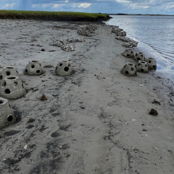
The virtual tour below allows visitors the ability to virtually walk around the east renovation area at Kingsley Plantation. Visitors can walk around the POSH structures at low tide and view the surrounding area showing the beach erosion and lack of vegetation.
Support Provided by RTS Staff
-
Advanced Photography Techniques
The Research Technology Services (RTS) team conducted the initial site assessment of two shoreline areas at Kingsley Plantation, identified as sites experiencing erosion. Utilizing advanced methodologies, including drone and pole photography, the RTS team generated orthorectified aerial imagery of these locations. Employing a high-accuracy Global Positioning System (GPS), they produced Digital Elevation Models (DTMs) with centimeter precision.
Orthorectified aerial imagery is a type of aerial photo that has been corrected to fix any distortions, like uneven land or camera angles. This makes the images accurate for measuring and mapping as if you're looking at a flat map, which helps in planning and analyzing areas.
-
Application of Imagery
The imagery resources were then utilized by faculty and students in the Civil Engineering and Biology departments to strategize the implementation of Pervious Oyster Shell Habitat (POSH) and Reef ball structures, aimed at mitigating and rectifying shoreline erosion.
-
Ongoing Monitoring and Evaluation
After the deployment of the POSH and Reef Ball structures, RTS staff conducts regular visits to Kingsley Plantation to capture updated aerial imagery and DTMs for ongoing monitoring purposes.